- Resilion
- Sensors and monitoring
- Risks and outages
- Climate and extreme events
A possible return of El Niño in 2026 could intensify storms, wildfires, heat waves and other risks to transmission lines. Here is how to track the phenomenon and prepare each asset with predictive intelligence.
Resilion4 min read
In our last article, we mapped the villains that bring down towers and trip lines in Brazil, and found that nearly half of all collapses and outages trace back to weather. Now a familiar actor is getting ready to take the stage again, one that can amplify several of those risks at once: El Niño. Understanding it, following how it develops and tailoring asset readiness to it is what separates reactive operators from resilient ones.
What El Niño is
El Niño is the warm phase of a natural climate cycle in the equatorial Pacific known as ENSO (El Niño-Southern Oscillation). Every two to seven years, surface waters in the central and eastern Pacific warm above average and throw wind, temperature and rainfall patterns off balance worldwide. Its sister phase, La Niña, is the opposite: the same waters cooling down. In between sits a neutral phase. It is not a rare event: since 2014 there have been three El Niño episodes (2015-16, 2018-19 and 2023-24), covering about 22% of the period. It is one of the most predictable components of the planet's climate variability.
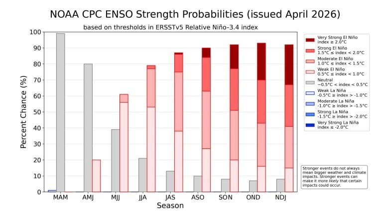
After almost two years under La Niña, NOAA* declared the cool phase over in April 2026 and issued what it calls an "El Niño Watch." Conditions are currently neutral, with an 80% chance of staying that way through June, but the probability of a new El Niño emerging between May and July is 61%, and it is expected to last until at least the end of 2026. More worrying is the range of possible intensity: between November 2026 and January 2027, the chances are roughly equal, about one in four each, that the event is moderate, strong or very strong, the last being the so-called "super El Niño," with an anomaly above 2°C. Experts urge caution before settling on the worst case, since the final strength depends on equatorial winds that can still change, but the warning is out.
What about Brazil?
In Brazil, the typical effects of El Niño are well known and vary by region. In the South, and especially in Rio Grande do Sul, rain becomes more frequent and heavier, with a higher risk of extreme events in spring and summer, as seen in 2015-16 and again in 2023-24. In the North and Northeast the pattern flips: below-average rainfall, severe droughts, a delayed rainy season and greater vulnerability to wildfires. In the Center-West and Southeast the effect is subtler but insidious: irregular rain, prolonged heat waves and low air humidity, a combination that has historically raised fire risk sharply.
For the transmission sector, each of these effects maps to a risk vector that is already familiar. In the South, more storms mean more gusts and more lightning strikes, plus branches blown into the conductors: exactly the causes behind the 45% of tower collapses and 47% of outages that ONS, Brazil's national grid operator, attributes to weather. In the North, Northeast and Center-West, more frequent and more intense wildfires feed the 28% of outages caused by fire, by ionizing the air around the lines. And there is an indirect effect, silent and systemic: heat waves push demand up across the country, stressing conductors that already run close to their thermal limit and magnifying the impact of any outage. El Niño does not invent new risks. It amplifies several that operators already know, all at once.
How do you prepare when the odds are still uncertain and shifting?
The answer is neither to plan for the worst case nor to ignore the warning. It is to match preparation to each asset's most likely risk, taking into account the region, the maintenance history and the line's specific vulnerabilities. A tower in Rio Grande do Sul with accumulated fatigue needs a different kind of inspection than a line in Mato Grosso surrounded by dry vegetation. Following ENSO closely, building seasonal forecasts into operational planning and combining IoT sensors, satellite imagery and predictive intelligence becomes the path to resilience itself. At Resilion, we believe that when the outlook is uncertain and changing, those who see it coming sooner make better decisions, and that visibility is what keeps the grid energized even when the climate shifts.
*NOAA stands for National Oceanic and Atmospheric Administration, a scientific and regulatory agency of the U.S. government under the Department of Commerce.